In my previous post I wrote about sakura viewing at Maruyama Kouen (丸山公園), a park located on Mt. Iwadonosan where you find what is said to be Japan's best view of Mt. Fuji. For people who would like to do some more hiking than just the 20 minutes long walk to the castle it is possible to continue by foot up to the top of Mt. Iwadonosan.
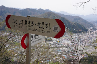
There’s a path right behind the Iwadono Castle, and it is easy to find the way to the top as long as you stick to this path. There are some road signs on the way that will help you find the way, and if you decide to change course and head towards the Kabutoiwa / Chigootoshi you'll also find signs showing you where to turn.


In our case we continued to follow the path to the top of Mt. Iwadonosan. Once you reach the summit you'll find the following stone monument:

We visited Mt. Iwadonosan during the sakura season, and on the top of Mt. Iwadonosan there were many pretty cherry trees in bloom. It was slightly more crowded at the top of Mt. Iwadonosan than by the castle when we visited, but still nothing in comparison to cherry blossom spots in Tokyo.

 |
| Back to the road sign leading to Chigootoshi |
 |
| Unfortunately the weather wasn't that clear so it was slightly hard to see Mt. Fuji |

View towards Mt. Iwadonosan
After having surpassed Kabutoiwa the next place coming up was Chigootoshi (稚児落とし). The name “Chigo otoshi” literarily means “baby dropping”, and has its name from historical events that took place here. You can probably guess the details.. It was quite steep, and without a doubt a deadly place should one be so unlucky as to fall down (or be dropped).
View from the edge of the Chigootoshi
From Chigootoshi we continued to follow the path and ended up by the main road. From there we followed the road signs in the direction of the station, only with a few stops along the way to check out our surroundings. Here are some of my pictures from the way back:
A river by the roadside
An old bridge
The Chuo Expy (Toll Road) bridge
All in all it was a very nice one-day trip from Tokyo and a great hike. If you have around 3-4 hours you should have no problem to finish the hike. There are a couple of restaurants by the Ootsuki (大月) station, and we enjoyed a big bowl of ramen at one of the restaurants before heading back to Tokyo. You can find a simple map of the hiking trail we followed to the left.
Related blogposts
- All blogposts from Yamanashi Prefecture
- All blogposts about Mt. Fuji
- Climbing Mt. Fuji!
- Traveling Japan: Mt. Fuji and its Vicinity
- Mt. Fuji & Sakura Viewing: Maruyama Kouen (丸山公園) and Iwadono Castle (岩殿城)
- Hiking in Yamanashi: The view of Mt. Fuji from Mt. Iwadonosan to Chigo-Otoshi
- Paragliding in Japan: Panorama View of Mt. Fuji with Sky Asagiri (スカイ朝霧)
- Roundtrip in Japan: Hakone & Mikawaya Ryokan
- All blogposts about Hiking
- Hiking in Yamanashi: The view of Mt. Fuji from Mt. Iwadonosan to Chigo-Otoshi
- Mt. Fuji & Sakura Viewing: Maruyama Kouen (丸山公園) and Iwadono Castle (岩殿城)
- Sightseeing in Chiba: Hiking Mt. Nokogiri (鋸山)
- Hiking in Tochigi: Sandogoya Onsen, Mt. Chausu and Mt. Asahi
- Hiking in Tokyo: Sakura viewing (花見) at Mount Takao
- Hiking in Kamikōchi - The Japanese Alps: Mt. Chōgatake (蝶ヶ岳)
- Hiking in Kamikōchi - The Japanese Alps: Mt. Yake (焼岳)
- Sightseeing in Japan: Climbing Mt. Fuji!
- All blogposts about Sakura
Recommended Hotels close to Mt. Fuji
|
Hotel Kaneyamaen |
Fuji Royal Hotel Kawaguchiko |
Kawaguchiko Country Cottage Ban |
This page contains affiliate links, and if you follow a link and make a hotel reservation through these links you help support this blog without any additional cost to you. Thank you so much for your kind support!


Leave your comment
Post a Comment