Adventures of Anette: Hiking
Showing posts with label Hiking. Show all posts

Saturday, December 8, 2018

Saturday, July 21, 2018

PNG: All You Need To Know About the Tavurvur Volcano Hike

7:36:00 PM
Tavurvur (the black peak in the middle) and volcanic orange sand
Photo: Anette

Tavurvur is often referred to as one of Papua New Guinea (PNG)'s most dangerous volcanos. The nearby city Rabaul, once known as the 'jewel of the Pacific', used to be the provincial capital of the East Britain island until an eruption from the volcano destroyed big parts of the city in 1994. Although its last eruption occurred as recent as in 2014, the volcano has become a popular place to visit for tourists to the area, and when we visited the island for the National Mask Festival it was a natural destination for a day trip from our base in Kokopo.

Sunday, October 22, 2017

Brunei: A Day Trip to the "Green Jewel of Brunei" Ulu Temburong National Park

8:14:00 PM
During our stay in Brunei the most exciting experience we had was when we went for a day trip to Brunei’s first National Park called Ulu Temburong. This area is a part of the Batu Apoi Forest reserves and it has been under protection as a safe haven for nature since 1991. In fact, up until revent years it was only accessible for researchers. These days the area is also open to low impact Eco-tourism, so if you're interested in a unique glimpse into the life in the jungle this is definitely something for you. In addition to the jungle adventure we also stopped by a long-house, the authentic home of a family in the local Iban tribe. You can read more about this in my next post, but without further redo here's a short introduction to our jungle adventure.

Sunday, May 21, 2017

Hiking in Tokyo: Mt. Fuji View from Okutama's Mt. Mito (三頭山)

10:35:00 PM
Believe it or not; you don't even have to leave Tokyo to find good hiking spots. The metropolitan area of Tokyo stretches far outside the city itself, and in the area west of Tokyo known as Okutama you can find a number of popular hiking destinations. 
Many people have heard about or visited the popular and accessible Mt. Takao which also can be found to the west of Tokyo, but there are other lesser known mountains that can provide an interesting alternative to this slightly crowded favorite. One of my personal favorites is Mt. Nokogiri in Chiba, where you in additional to enjoying the hike also can see some traditional temple and not to mention Japan's largest Buddha statue cut from a single rock. For this trip, however, we went to check out Mt. Mito (三頭山) in Okutama, a mountain known most of all for its good view of Mt. Fuji. 
Mt. Mito has been listed as one of Japan's top three hundred mountain destinations(日本三百名山), and stands at a height of 1,531 meters above sea level. Situated in the western part of Okutama this hiking destination can be reached either by car or by bus from the nearest station (check my table at the bottom at this post for more details).
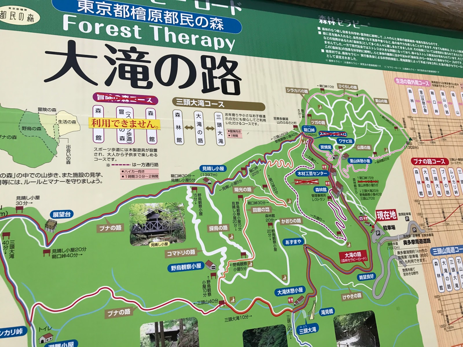
In our case we took the train to Akikawa Station (秋川駅) where we rented a car heading toward the starting point of the hike; the Citizens’ Forest (tomin no mori 都民の森). Here they have a number of courses you can choose from with varying difficulties. We chose the Bunanoro Course (ブナの路コース), a hike estimated to take approximately 3-4 hours.
But first, when you arrive at the tomin no mori area you'll find a souvenir shop selling local products. This is the last shop you get to before the hike so if you're hungry you might want to try out some of the food they sell.

After a few minutes of walking from the parking lot area there is a building called the shinrinkan (森林館) where visitors among other things can find information about the wildlife and flora in the area.


During the Edo period Mt. Mito was kept off limits to the public, and thanks to this you can find a wide range of large beech trees covering the mountain. This might have contributed to Mt. Mito's particularly varied flora with both rare plants and birds to be seen in the woods.

And don't despair if you didn't bring any hiking booths; At the Shinrinkan they have mountain boots available for rental. They also kindly offer maps of the area in foreign languages like English, Korean and Chinese.


For those who are looking for activities to do beside the hiking there is an area outside the Shinrinkan where visitors can try to use a saw to cut up logs, and you're even free to take the pieces of wood with you home.

For those with kids there are some playground equipment that they can enjoy.

In other words; lots of potential activities in addition to just the hike! When you're ready for the hike you can head for the pathway behind the building to the left of the mountain.


Above: On Mt. Mito you can see a number of birdwatchers who are out to spot some of the mountain's rare birds.

The first sight you'll get to is the Mito Otaki Waterfall, which you'll get to after around 25 minutes of walking. There is a suspension bridge leading to nowhere that has been made just for the sole purpose of getting a good view of the waterfall, so if you want to you can take the opportunity to walk out on it and take a closer look before heading back to the main path.

For the rest of the hike you'll pass by a couple of resting spots before reaching the summit of Mt. Mito. The trail is properly marked so it is easy finding the way, and there are not too many visitors either compared to more popular mountains.


Arriving at the summit of Mt. Mito you'll find - if you're lucky with the weather - a pretty spectacular view of Mt. Fuji. I recommend starting the hike early to increase your chances of seeing Mt. Fuji more clearly as it often gets increasingly clouded throughout the afternoon due to the heat from the earth.

Getting up to the summit took us around 1 1/2 hours and it was not a too tough hike. We had a lunch break on the top (again, make sure to bring your own lunch as there are no places to buy food at the summit) before heading back down again.

Above: On the way down you'll also pass by a couple of lookouts where you can enjoy the view of the nearby mountains.

Mt. Mito was a good alternative for a one-day hike from Tokyo. It is great to get out of the city and do some shinrinyoku (森林浴; lit. forest bathing) from time to time to release some stress! After the hike was over we visited a local onsen, which I would recommend as an addition to your hike if you have time (and preferably a car to get around). Hiking Mt. Mito was a great way to spend the day, and hopefully we'll get the chance to visit again soon.

That's all for now, I hope you enjoyed the post! Please let me know if you have any questions or comments in the comment section below.
-Anette

Basic Info
  • ・Place: Mt. Mito (三頭山)
  • ・Address:Kouchi Okutama, Nishitama District, Tokyo 198-0224
  • ・Height: 1,531 m


Related blogposts


Recommended Hotels in Tokyo

Robot Hotel - Henn na Hotel Maihama Tokyo Bay
Henn na Hotel
 → review
Bunka Hostel Tokyo
Bunka Hostel Tokyo
Hundred Stay Tokyo Shinjuku
Hundred Stay Tokyo
 → review
Kaisu Hostel
Kaisu Hostel


This page contains affiliate links, and if you follow a link and make a hotel reservation through these links you help support this blog without any additional cost to you. Thank you so much for your kind support!


Thank you for reading! Please feel free to leave any comments or questions below
- Anette

Monday, April 25, 2016

Hiking in Yamanashi: The view of Mt. Fuji from Mt. Iwadonosan to Chigo-Otoshi

4:00:00 PM

In my previous post I wrote about sakura viewing at Maruyama Kouen (丸山公園), a park located on Mt. Iwadonosan where you find what is said to be Japan's best view of Mt. Fuji. For people who would like to do some more hiking than just the 20 minutes long walk to the castle it is possible to continue by foot up to the top of Mt. Iwadonosan. 

Sunday, April 24, 2016

Mt. Fuji & Sakura Viewing: Maruyama Kouen (丸山公園) and Iwadono Castle (岩殿城)

4:11:00 PM
From the Ootsuki Tourism Association
If you're visiting Japan during spring you’re probably keen to get a good look at the sakura, Japan's unofficial national flower. While the spots where you can view cherry blossoms in Tokyo usually are extremely crowded you can find many equally or more beautifully picturesque sakura spots in the areas close to the metropolis. And then again, as a tourist you might want to combine the view of the sakura with other things that are typical for Japan. If that is the case then I would recommend a trip to Yamanashi Prefecture to see Mt. Fuji from Mt. Iwadonosan.

Sunday, November 29, 2015

Sightseeing in Chiba: Hiking Mt. Nokogiri (鋸山)

9:26:00 PM

Chiba Prefecture is one of the three prefectures surrounding Tokyo, along with Kanagawa (Yokohama) and Saitama. Although Chiba is most known for Narita airport and Disneyland (yes, it is in fact not situated in Tokyo despite the name) the prefecture also has a lot of other things to entertain its visitors such as beautiful beaches, great mountains for hiking and hot spring ryokan. 

Thursday, May 21, 2015

Sightseeing in Hong Kong: The Dragon Back Hiking Trail

11:08:00 PM
Although Hong Kong is more renowned for its many shopping opportunities and delicious food than for its natural surroundings the city is actually situated close to beautiful mountains providing great hiking opportunities for those who long to get away from the bustling city life. 
For Yuma and me this hike was in fact the first thing we chose to do for our stay in Hong Kong. Neither of us are particularly found of shopping, and as the first day of our vacation fully at our disposal we decided to charge our batteries.

The bus terminal at Shau Kei Wan
Finding the way to the hiking trail was relatively easy. First we took the metro to Shau Kei Wan Station where the bus terminal was located by exit 3, and from there we got on bus number 9. The bus took us up the mountains and into the wilderness, and we almost didn't notice it when the buss passed by Tei Wan, where we were supposed to get off. 
A sign showing the way to the Dragon's Back
On the side of the road there was a small sign with the dragon symbolising the trail we were taking; the Dragon's Back. Apparently this track is very well considered among travellers, and in 2004 it was even selected by TIME Asia as the best urban hiking trail. Although the trail was situated in the middle of nowhere they still had done a good job with ensuring that visitors had access to toilets and even a box with a button one could press in case of emergency.
Prepared for all sorts of emergencies
From the main road we went straight into the bushes and the wilderness and soon we found ourselves in the middle of a small bamboo forest.
The beginning of the trail
It didn't take long though until the vegetation grew thinner and shorter, and soon we reached an area where we had a good view at the nearby peninsula on the other side of the bay.
Along the trail we could see the beaches stretching out far below us, and we could also glimpse some islands far out at sea.

As we got closer to the top it got pretty hot, not that much because of the physical effort of following the trail but rather because of the lack of vegetation. The sun was burning hot!

All along the way we had beautiful view though. It was fantastic to get out of the city and get to relax in the nature.
The Dragon's Back
At the latter half of the hike we got to the area which gave the Dragon's Back its name.

We reached the top of the Shek o Peak at 284 meters, and rested at one of the benches there before starting the descending.

Apparently the hike takes about 1-2 hours to complete. In our case we weren't really in a rush, so we went quite slowly and probably spent a little bit more than two hours on the hike.

After a couple of relaxing hours with long breaks on the way we reached the end of the trail. This place was situated right by a beach known as the Big Wave Bay Beach, and it seemed that a number of other foreigners also had discovered this hidden gem already.
Some cute houses at the end of the trail
Some local stores selling all you might need for a trip to the beach
The Big Wave Bay Beach
After a lunch at a local restaurant we went down to the beach too. We spent some time strolling on the sand dunes before heading back to Hong Kong.

Right by the beach there was a bus stop where the same bus we used to get to the trail also stopped at. It was easy to get back to the city, and after having returned to Shau Kei Wan we enjoyed one of Hong Kong's specialities, the egg tarts at a bakery in the nearby food market.
One of Hong Kong's many specialities; the egg tart. Delicious!

Thank you for reading! Please feel free to leave any comments or questions below
Anette


Related blogposts


Recommended Hotels in Hong Kong

Royal Plaza Hotel
Royal Plaza Hotel
JJ Hotel
JJ Hotel
Kimberley Hotel
Kimberley Hotel
Harbour Grand Hong Kong Hotel


About Me

Adventures ofAnette


A modern day shield-maiden who loves to explore the unbeaten paths of the world. From her base in Tokyo, Anette takes on both rural and urban challenges, and goes by the motto "No challenge too big, no adventure too small"!
・Read more →


Recent Posts

recentposts

Random Posts

randomposts